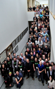
Last week, from 4th to 10th March, the QGIS International User and Developers Conference was held in A Coruña, Spain. QGIS is one of the most important free and open source software for GIS. It offers a wide range of tools and functionalities for viewing, editing and analyzing geospatial data. Organized by the QGIS Spanish Association, the conference gathered more than 140 demanding and enthusiastic users and developers.
For the first time UNIGIS Internation Association was acting as Silver sponsor of this conference. Thanks to the organizers for offering this opportunity! Furthermore Josep Sitjar (@JosepSitjar) and Lluís Vicens (@lluisvicens) from UNIGIS Girona were contributing with an interesting workshop. They are sharing their experiences of this inspiring conference with us in this post.
The Workshop days
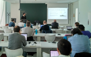
The first two days of the conference were focused on workshops. These activities were organized into four-hour sessions and explicitly dedicated to working in a practical way, including quite many different aspects and applications of QGIS. In summary, 9 workshops of various thematic issues were taught. The workshops covered quite different aspects and functionalities. On the following lines, we would like to tell you a little bit about them (at least from those that we could attend).
«Taking full advantage of drone imagery with QGIS» demonstrated how to visualize and process images and point cloud data acquired with a drone, on QGIS. Jorge Gustavo (@estibordo) and Lene Fischer (@Lene_Fischer), co-instructors of the workshop, presented the main characteristics and advantages of working with this kind of tools and processes. During the workshop, a principle was explicitly verified: most of the drones are made for exterior use! Outdoors is mainly their preferred habitat.
Under the title of «Automating your GIS workflows using QGIS», Ujaval Gandhi (@spatialthoughts) imparted a very interesting workshop focused on showing the potential and importance of automating processes in QGIS, both making use of batch processing and the graphical modeler. Workshop’s slides and data are accessible from the following link: http://bit.ly/automating-gis-workflows.
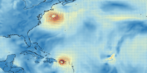
Kurt Menke (@geomenke), on his workshop «Data Visualization and cartography in QGIS», did an exhaustive overview of the tools and different techniques to visualize our data in QGIS. It was a really practical session to enlarge the quality and the readability of our maps designed with QGIS. Kurt also introduced the 3D and temporal QGIS environment to visualize such kind of particular data. As an example, we loaded a mesh layer (one of the brand new formats supported by QGIS 3.x), in order to visualize meteorological data in a dynamic way: looking at the movement of hurricanes and tropical storms.
Dynamic visualization of meteorological data with QGIS.
In the workshop «QGIS server with Python superpowers», Alessandro Pasotti (@elpaso66) showed us the workflow to configure QGIS Server in order to publish our data, based on the use of several standards such as WMS, WFS, WCS or WMTS. The session based on the use of an Ubuntu Server, where we installed and configured all the necessary tools (Apache, Nginx, …) to reach the goals of the workshop.
The last workshop we could attend was titled «QGIS Atlas, tips and tricks» by Alexandre Neto (@AlexNetoGeo). As is clearly stated in the title, it focused on the Print Composer module of QGIS, and more precisely, on the Atlas feature. The main goal of the workshop was to present a list of tricks and shortcuts to design and generate an atlas in a more agile, quick and smart way.
Finally, Josep Sitjar (@JosepSitjar) and I (@lluisvicens) held a workshop titled «Image processing and land cover change detection with QGIS». The slides and the data can be accessed from the following link: https://t.co/p1G4mDfdhO.
The conference day – Quite diverse talks and presentations
The QGIS evolution.
Joana Simoes (@doublebyte) gave the opening talk of the conference. She centered her presentation («My Journey Through QGIS») in showing the evolution of QGIS from its birth, in parallel of her professional life: from 2002 as a simple data viewer up to nowadays. In a timeline, Joana placed the different versions pointing out its main functionalities and improvements at that particular time, while revealing the massive and continued effort from the developer community to make QGIS bigger and better, over the years.
 The Conference counted on more than 35 talks.
After the opening talk, the audience started to move between rooms because the program was divided into two separate tracks. The topics were quite diverse, from new features of QGIS 3.4 designed for 3D visualization, plugins such as DataPlotly for graphics generation, or the EO Time Series Viewer for visualizing remote sensing temporal data series. New developments were also shown such as IQUAview. The team of IQUA Robotics presented an architecture based on QGIS to plan missions with subaquatic vehicles. Moreover, we could attend a good bunch of different case uses and projects where QGIS was obviously the main actor, such as the talk «Is London a forest?», given by Ariadni-Karolina, that presented a new methodology to evaluate the presence of vegetation in London. This is just a short glimpse of all the beautiful presentations that we had the chance to attend.
In any case, the entire program was wide and interesting enough so we really encourage readers to keep an eye over the #QGISUserConf2019 twitter hashtag, as well as on the Conference website, to locate and find the slides of most of the presentations and also for the recordings that are yet to come!
The QGIS Ecosystem
Finally, Víctor Olaya concluded the conference day giving a keynote titled «Ecology of the QGIS ecosystem». During a little bit more of half an hour, Victor reflected about the role that the companies that use QGIS should or could play. Should these companies ethically be obliged to contribute economically or by contributing new code to the QGIS project? What type of relation -commensalism, parasitism, mutualism- can be established between companies and the QGIS project? As usual, Victor gave a very inspirational talk. And as a summary, we kept the idea that there are several and multiple ways of contributing back to a project such as QGIS. Which is better? It depends.
The hackmeeting
The «party» continued all over the second half of the week (until Sunday) with the hackmeeting, although we could not attend it. However, taking a look at the hashtag mentioned before, it is obvious that it was also a successful event, full of code, new improvements, and fun.
UNIGIS: sponsor of the QGIS Conference
Besides the new knowledge acquired, we also had time to meet three MSc students from UNIGIS Girona that were also attending the Conference. Two of them took advantage of grants offered by the UNIGIS International Association.
We can conclude that our three days spent in A Coruña were really profitable. It was a quite nice experience to learn and share knowledge and practices on QGIS. And last but not least, we would like to say BIG THANKS and sending a hug to the organizers. Team, you did an amazing and unforgettable job. Congratulations!
© Text and Pictures by: Josep Sitjar and Lluís Vicens, UNIGIS Girona