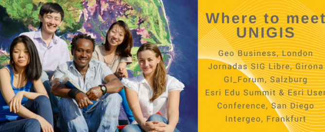
Where to meet UNIGIS
Meet UNIGIS at GIS events worldwide What is distance learning? What are the prerequisites for the different programmes? Where to study with UNIGIS? What would be the most suitable geoinformatics study programme? You ever wanted to meet the people behind UNIGIS? Take the chance and visit UNIGIS International Association and UNIGIS Institutions at one of the leading GIS events this year. We are looking forward to meet current UNIGIS students, alumni and all of you interested in Geoinformatics and distance learning. UNIGIS will be present at the following events: 22-23 May: Geo Business, London, UK June 7-8, 2018: GEOSummit 2018, …
Read more…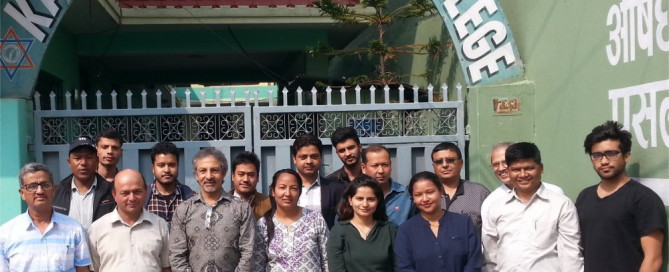
UNIGIS Kathmandu – Celebrations & Events
UNIGIS@Kathmandu (Nepal) celebrated the 5th year of its inception at Kathmandu Forestry College (KAFCOL) on 28th April, 2018. Dr. Him Lal Shrestha (Coordinator, UNIGIS Kathmandu) opened the event with a welcome note to the Board Members, UNIGIS students and module instructors. He also thanked Dr. Shahnawaz (Director, UNIGIS S/E Asia) and Dr. Jhamak Karki (Vice Principal, KAFCOL) for their presence in this event. Dr. Shahnawaz led an orientation workshop with 12 new students starting their UNIGIS MSc studies. Prof. Josef Strobl delivered an online lecture outlining strategies for a successful learning process, and discussing with students current skills and competences …
Read more…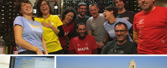
UNIGIS Girona celebrating its 20th anniversary!
Right from its beginnings, the GIS and Teledetection service (SIGTE http://www.sigte.udg.edu/) of the University of Girona embraced the UNIGIS Girona project, and has made it grow to what it is today. Getting this far has been an adventure in itself, a project of professional growth and personal experiences. However, UNIGIS Girona has reached the twentieth edition thanks to the contribution of each single person involved in the project: • almost 2000 alumni who trusted us and who paved their own way with our master’s degree; • tutors of the different modules; • contributors who have made possible the proper performance …
Read more…Making GI/EO professionals ready for the future!
The Earth observation (EO) and Geoinformatics (GI) sector is rapidly evolving due to technological advances, growing collections of open data (e.g. Copernicus), and a broader user base. This evolution requires the adaptation of EO/GI training for matching the skills on demand most useful for the market and society. EO4GEO is an Erasmus+ Sector Skills Alliance project, aiming at bridging the skills gap between supply and demand of education and training in the space/geospatial sector and gathering 26 partners from the education/training and space/geospatial sectors. Most of the partners from academia, private and public sector are part of the Copernicus Academy …
Read more…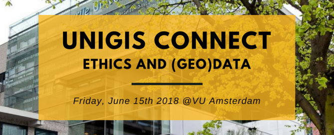
UNIGIS Connect @VU Amsterdam
UNIGIS Connect 2018: Ethics and (geo)data This annual event at VU Amsterdam is connecting UNIGIS students (current and eternal), alumni, staff and anyone interested in UNIGIS. It will provide an excellent opportunity for networking within the Geospatial community, gaining new knowledge and obtaining inside information about the various study programmes offered through UNIGIS. The plenary will focus on the ethics of (geo)data. In the afternoon there will be several presentations by students. Stay tuned for the exact programme, a call for papers, the keynotes and the logistics of the conference. Location: VU Amsterdam, De Boelelaan 1105, 1081 HV Amsterdam, route. …
Read more…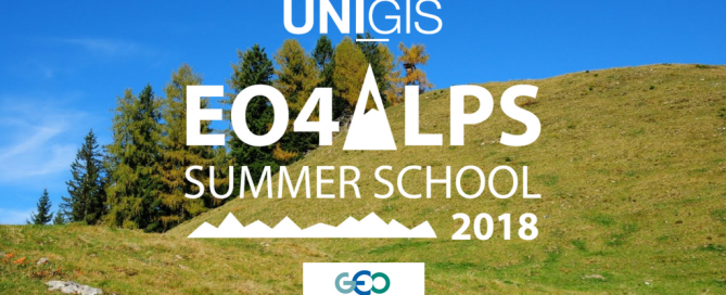
EO4Alps Summer School, June 24 – July 6, 2018l
“Earth observation and geospatial information: supporting a sustainable use of alpine ecosystems and water resources” The EO4Alps Summer School 2018 is jointly organized by University of Salzburg, Department of Geoinformatics (Z_GIS, www.zgis.at) and the Group on Earth Observations (GEO, www.earthobservations.org) and will be held in Salzburg, Austria, June 24 – July 6, 2018. Alpine areas show high spatial variability due to complex terrains, steep vertical gradients in climate elements, and inhomogeneity induced by transitions between vegetation zones and to the cryosphere. The resulting patterns of climate and climate change are often highly complex and very demanding in terms of monitoring, modelling, and …
Read more…
UNIGIS Geospatial Events Grants 2018
UNIGIS International Association “Geospatial events grants” (GEG) – Now open for applications! Established in 2017, the UNIGIS International Association for the first time awarded grants for participation in a leading Geospatial event. The aim is connecting UNIGIS students with the international geospatial community, So far, six UNIGIS students have been selected for funding and benefitted from presenting their work to a broad and international audience. You can learn more about their experiences on our blog. In 2018, two calls will be launched: Call spring 2018: application period March 1st – April 30th Call autumn 2018: application period October 1st – …
Read more…
Meet UNIGIS at the Geospatial World Forum 2018
Geospatial World Forum, the premier annual global geospatial event, will take place on 17-19 January 2018 in Hyderabad, India. The conference expects participation from 3000+ participants from across the globe. Under the umbrella theme of “GEO4IR: Geo-enabling 4th Industrial Revolution”, the 10th iteration of GWF will touch upon digital disruption, which is at the heart of 4th industrial revolution. The 3-days conference will begin with inaugural and plenary sessions, followed by various thematic sessions on Smart Cities, Construction & Engineering, Location Intelligence, Defense and Public Security, Agriculture, AI and IoT, Sustainable Development Goals, Employability, Regional Cooperation, and others. The conference …
Read more…
UIA Business Meeting @VU Amsterdam
During the last week of November UNIGIS Program directors have met at the Vrije Universiteit Amsterdam to discuss future development of distance learning for geospatial professionals worldwide. Throughout the meeting various information and discussion sessions were held on topics of elearning, curriculum, new resources and educational materials as well as virtual exchange of students and marketing actions. Dedicated to Dissemination, the first day of this annual meeting was concluded with a joint participation at the GEO|Design+BIM 2017 conference education panel and a meeting with industry partners. The UNIGIS International Association board of directors used this opportunity to announce the designation …
Read more…
UNIGIS Geospatial Events Grant: Congratulations to new Grantees!
This year the UNIGIS International Association established the “Geospatial Events Grant” (GEG), to connect active UNIGIS students with the international geospatial community and enhance the learning experience beyond lessons and exercises. We are now pleased to announce the grantees within the second Call of this Grant! Two UNIGIS students have been awarded a grant for participating in a leading Geospatial event and presenting their work to a broad audience: Oscar Londoño, Master student at UNIGIS AmericaLatina, receives a grant for attending the Esri Health and Human Services GIS Conference 2018. Mr. Londoño is a medical epidemiologist from Cali, Colombia and …
Read more… Previous Next