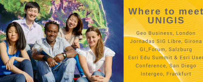
Where to meet UNIGIS
Meet UNIGIS at GIS events worldwide What is distance learning? What are the prerequisites for the different programmes? Where to study with UNIGIS? What would be the most suitable geoinformatics study programme? You ever wanted to meet the people behind UNIGIS? Take the chance and visit UNIGIS International Association and UNIGIS Institutions at one of the leading GIS events this year. We are looking forward to meet current UNIGIS students, alumni and all of you interested in Geoinformatics and distance learning. UNIGIS will be present at the following events: 22-23 May: Geo Business, London, UK June 7-8, 2018: GEOSummit 2018, …
Read more…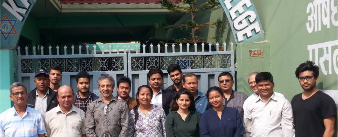
UNIGIS Kathmandu – Celebrations & Events
UNIGIS@Kathmandu (Nepal) celebrated the 5th year of its inception at Kathmandu Forestry College (KAFCOL) on 28th April, 2018. Dr. Him Lal Shrestha (Coordinator, UNIGIS Kathmandu) opened the event with a welcome note to the Board Members, UNIGIS students and module instructors. He also thanked Dr. Shahnawaz (Director, UNIGIS S/E Asia) and Dr. Jhamak Karki (Vice Principal, KAFCOL) for their presence in this event. Dr. Shahnawaz led an orientation workshop with 12 new students starting their UNIGIS MSc studies. Prof. Josef Strobl delivered an online lecture outlining strategies for a successful learning process, and discussing with students current skills and competences …
Read more…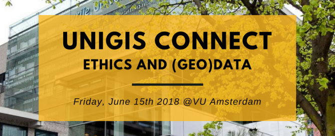
UNIGIS Connect @VU Amsterdam
UNIGIS Connect 2018: Ethics and (geo)data This annual event at VU Amsterdam is connecting UNIGIS students (current and eternal), alumni, staff and anyone interested in UNIGIS. It will provide an excellent opportunity for networking within the Geospatial community, gaining new knowledge and obtaining inside information about the various study programmes offered through UNIGIS. The plenary will focus on the ethics of (geo)data. In the afternoon there will be several presentations by students. Stay tuned for the exact programme, a call for papers, the keynotes and the logistics of the conference. Location: VU Amsterdam, De Boelelaan 1105, 1081 HV Amsterdam, route. …
Read more…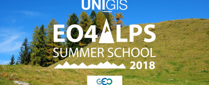
EO4Alps Summer School, June 24 – July 6, 2018l
“Earth observation and geospatial information: supporting a sustainable use of alpine ecosystems and water resources” The EO4Alps Summer School 2018 is jointly organized by University of Salzburg, Department of Geoinformatics (Z_GIS, www.zgis.at) and the Group on Earth Observations (GEO, www.earthobservations.org) and will be held in Salzburg, Austria, June 24 – July 6, 2018. Alpine areas show high spatial variability due to complex terrains, steep vertical gradients in climate elements, and inhomogeneity induced by transitions between vegetation zones and to the cryosphere. The resulting patterns of climate and climate change are often highly complex and very demanding in terms of monitoring, modelling, and …
Read more…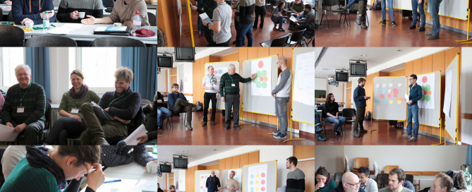
UNIGIS Professional Intro Workshop
A new group of UNIGIS Professional students gathered for getting to know each other and the local UNIGIS team in Salzburg last weekend. Again, it was a great opportunity to witness the integrative power and relevance of GIS. The new students have such diverse backgrounds, which range from forestry over crime scene forensics to the real estate business. However, all students are convinced that their career can be boosted by spatializing their respective expertise. We are glad to support this goal at UNIGIS. In the next months these students will not only work through learning materials. Neither will they simply learn …
Read more…
u_Lecture webinars fall/winter semester 2017/18
Starting from October, we are looking forward to an exciting roster of outstanding speakers on a range of topics covering themes of current interest for UNIGIS alumni, students, and everyone else. The open u_Lecture webinar series offers a LifeLongLearning opportunity to graduates and everyone keen to follow developments across the exciting field of Geoinformatics. See below for details on upcoming talks, and preview further speakers we keenly anticipate this term: >> Make sure you mark your calendars not to miss these unique opportunities to learn from and interact with these outstanding individuals! Jan 31, 5pm CET >Register for recording >Richard …
Read more…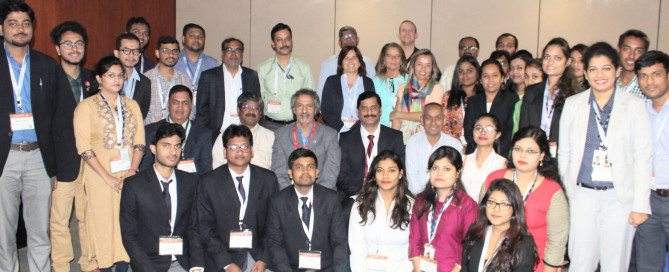
UNIGIS @ Geospatial World Forum 2018, Hyderabad
The UNIGIS International Association was invited to contribute to the Geospatial World Forum 2018 (GWF’18) conference held in Hyderabad, India from 15th to 19th January 2018. GWF is the largest conference in India focussed on geospatial themes in this country as well as around the globe. GWF is being annually organised in India or at venues in Europe. UNIGIS has been entrusted with a prominent role contributing as knowledge partner to multiple activities over several years. Prof. Josef Strobl (Chair, UNIGIS International Association) had the honour of delivering the prestigious Dr. Roger Tomlinson Memorial Lecture on January 17, attracting an …
Read more…
UNIGIS Fernstudium – Info-Webinar für die Jahrgänge 2018
Sie sind beruflich und/oder familiär engagiert und wollen trotzdem an der Universität studieren? Sie arbeiten vielleicht sogar schon mit GIS Werkzeugen und wollen die ‘Konzepte dahinter’ besser verstehen? Sie wollen ihre Karriere fördern, oder sind einfach nur neugierig auf neue Herausforderungen? UNIGIS MSc startet am 1. März 2018 – Anmeldung ab sofort möglich (bis 15. Februar 2018) UNIGIS Professional startet am 2. Februar 2018 – Anmeldung ab sofort möglich (bis 15. Jänner 2018) Informationen rund um die UNIGIS Fernstudien an der Universität Salzburg erhalten sie im Zuge eines online Webinars. Wir freuen uns auf ihre Fragen! Wann: Dienstag, 5. Dezember 2017, …
Read more…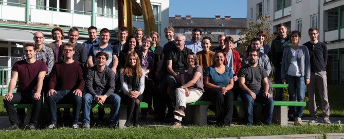
Master Thesis workshop – UNIGIS MSc 2016
“The Jadeit Connection: Modelling sea-routes in the Neolithic Aegean” and “Applying GI-Methods on localized IoT-devices and systems for interactive steering of Businesses processes” are only two Master Thesis topics showing the wide range of GIS. The UNIGIS Master Thesis workshop was held on 28 and 29 September 2017 in Salzburg, where 30 students from Germany, Austria and Switzerland presented the current status of their Master Theses, based on very diverse educational and professional backgrounds. The UNIGIS MSc team is wishing all the best and sucess with the tasks ahead.
Read more…
UNIGIS Winter School ‘Spatial Simulation Modelling’
UNIGIS Salzburg is offering a Winter School from February 15 – 24, 2018 in Salzburg, which addresses students and early career researchers interested in spatially explicit simulation of natural and/or social systems by the means of agent-based modelling. Individuals from domains such as Geoinformatics, Geography, Ecology, Social Science, Spatial Planning, or Forestry are welcome. Interest in computational methods is a prerequisite, but no prior knowledge in modelling or programming is needed. Organising lecturers: Prof. Andreas Koch (Social Geography, University of Salzburg), Ass. Prof. Gudrun Wallentin (Geoinformatics and Ecology, University of Salzburg) Location: University of Salzburg, Unipark Nonntal Description: Simulation models …
Read more… Previous Next