Next UNIGIS course for Central Asia students
The UNIGIS study centre for Central Asia at ACA*GIScience in Bishkek has now opened the registration period for the next intake of distance learning students, starting with October 2012. Applications will be accepted until September 10, and candidates are expected to have a background in any ‘spatial discipline’ or experience in a GIS application domain. UNIGIS Central Asia offers tutoring in Russian language, but as an international program requires profound English language skills for working with study materials, complete assignments and communicate within the worldwide network of UNIGIS students and alumni. With a clear focus on continuing education for geospatial …
Read more…New students in Ecuador and Colombia
By the end of April, the UNIGIS site in Quito welcomed 70 new students from Ecuador, Colombia and other Latin American countries as new members of the UNIGIS community of learning. They will join of group of 250 active students that already are enrolled at the University San Francisco de Quito in Ecuador. Being part of an academic program that is tailored to the specific needs of GIS professionals in the emerging GIS-market between Patagonia and the Rio Grande opens up great opportunities for professional and personal development. Welcome – Bienvenidos!
Read more…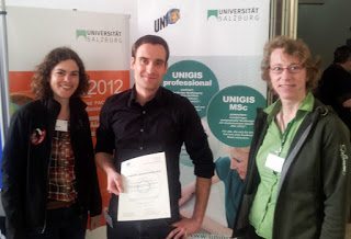
UNIGIS graduate winning top award at RTM!
Each year, the „Runder Tisch GIS“ at the Technical University of Munich awards prices for top theses in Geoinformatics. Outstanding Bachelor and Master Theses as well as PhD Dissertations compete for this distinction, with winners being announced and their work presented within the framework of the annual “Münchner Fortbildungsseminar Geoinformationssysteme”: Today, UNIGIS Salzburg alumn Matthias Boedecker received the 1st prize for his excellent Master Thesis “Koordinierung thematischer Klassen unter Verwendung kartographischer Relationen” (see summary). Congratulations, Matthias, for this success, combined with best wishes for your professional future!
Read more…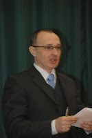
Top academic credentials for UNIGIS Hungary alumnus
Ervin Pirkhoffer PhD (UNIGIS alumnus, 2004-2006) held his habilitation (’second doctorate’) lectures at the Faculty of Sciences, University of Pécs on February 16. The titles of the lectures were ”GIS Approaches in Modelling” (lecture for students) and ”Flash Flood Modelling” (scientific presentation in Hungarian and in English). After acceptance of his professorial thesis, Ervin Pirkhoffer presented a scientific lecture on general features of flash floods and the impact of climate change on flash flood frequencies and magnitudes. Among the broad range of modelling approaches, he emphasized the findings of his research group. He outlined the strenghts of GIS applications in …
Read more…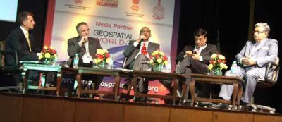
Directions of Geospatial Technology – India Geospatial Forum
At this year’s India Geospatial Forum in Gurgaon, Feb 7-9 Prof Josef Strobl from UNIGIS International was invited to the Plenary Panel on ‘Dimensions and Directions of Geospatial Technologies’. In a session joined by Dr. V K Dadhwal (Director NRSC India); Rajesh Mathur (Vice Chair ESRI India) and J. B. Monnier (Senior VP Bentley Asia), Prof Strobl was presenting ‘Live Geography’ as one of the key trends in today’s geospatial developments. India’s leading Geoinformatics event did not only again succeed in bringing together top decision makers, scientists and business representatives, but presented a rich industry exhibit and served as a reference platform …
Read more…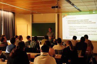
UNIGIS MSc: 2012 class is taking aim …
… at reaching their objectives! After having started their studies earlier this year, more than 50 new MSc candidates are convening at the University of Salzburg for their getting-acquainted workshop. A mixed agenda of introductions, orientation sessions on curriculum / modules / learning platform / approaches to study, plus reflecting on motivations and objectives for their studies keeps everybody involved. The main objective of the workshop of getting everyone off ‘to a good start’ into their UNIGIS MSc studies requires a clear focus on establishing communications and building a ‘community of learning practice’. This year’s group again has a diverse …
Read more…
UNIGIS Int’l: Thanks to Anna Szukalska!
Anna Szukalska from Krakow has managed the UNIGIS International Office for four years, coordinating meetings, communication and processes across all UNIGIS partner universities. In addition to managing external liaisons with industry partners and membership in associations, she assisted with marketing and ‘kept the wheels spinning’ when everyone else seemed to be busy with other tasks. With the end of 2012 Anna will hand over her responsibilities at UNIGIS International to her successor, and focus on her work at UNIGIS Poland. We will miss her motivating spirit and sense of duty, leading our Association into many initiatives which were not feasible before. UNIGIS Chair …
Read more…
2012 – Year of Career Advancement?!
Getting closer to the New Year means looking and planning ahead – what do I want to achieve as an individual, professionally, and in my career? For many of us this means further developing our competences and capacities, to continue our education and make sure to stay ‘ahead of the pack’! As Geoinformatics professionals, or with the ambition to establish ourselves in this rapidly growing and ‘future-proof’ discipline, this might mean to consider postgraduate studies. Not only because ‘geospatial’ is expanding as a job market, but also because there is rapid advancement and change in technologies: continuously ‘updating ourselves’ is …
Read more…
2011 UNIGIS Academic Excellence Awards
During the UNIGIS annual network meeting at USFQ in Quito, Ecuador, the 2011 winners of the UNIGIS Academic Excellence price recognizing top Master’s Theses were announced: Hugo MARTINS (UNIGIS Lisbon) SIGLA WEBGIS PORTAL: An Open Source Web-based GIS application for the Portuguese Bluetongue Entomological Surveillance Program. Stephanie BRAND (UNIGIS Salzburg) Roof surface classification with hyperspectral and laser scanning data – an assessment of Spectral Angle Mapper and Support Vector Machines. Peter WITT (UNIGIS UK) The development of a predictive hiking travel time model accounting for terrain variations. The jury with members from UNIGIS Krakow and Lisbon was chaired by Richard …
Read more…UNIGIS invited to INCA Conference in Chandigarh, India
UNIGIS was invited to contribute to the 31st Annual conference of the Indian National Cartographic Association (INCA) organised from 15th to 17th October, 2011 in Chandigarh, India (http://www.incaindia.org/). Dr. Shahnawaz was speaking on the “Dynamic Cartography for efficient Disaster Management”, illustrating how highly qualified individuals are key to leveraging the potential of GIS in these (and other!) application domains. During the opening session, Prof. Josef Strobl was invited to deliver the prestigious ‘Professor S. P. Chatterjee Memorial Lecture’ which is organised once every three years. Prof. Strobl discussed concepts around “Map Interfaces for Disaster Management” and demonstrated how GIScience …
Read more… Previous Next