
About the programme:
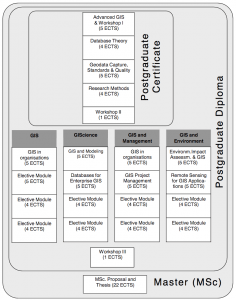 The Postgraduate Diploma in GIS is attained on completion of the Postgraduate Certificate course plus another four modules and another four-day workshop at the university, again organized in June. The PgD programme can be completed within two years. More information on the objectives of the different pathways and modules belonging to each pathway can be found here.
- Pathway 1: Geographical Information Systems This course is aimed at team leaders/managers with a need for general GIS training or specialists who require a broad coverage of the field. It is a broadlybased postgraduate qualification in the field of GIS which focuses on the principles of design in relation to systems, human computer interfaces and applications. There is a strong emphasis on the linkage between technology, data organisation and methods. It will support career development or career change. By providing a broad coverage of GIS field, it will support professionals seeking to extend and consolidate more focussed knowledge.
- Pathway 2: Geographical Information Science This course is aimed at people who want to develop careers in the technical and scientific areas of GIS or applications developers who want to specialise in GIS. Emphasis is placed upon design and organisational issues in the context of applications development. Experience in the use of software products and ofapplications development forms an important part of the course.
- Pathway 3: Geographical Information Systems and Management This course is aimed at established managers who have new or extended responsibility for GIS projects or at those seeking career development into more managerial roles and who need to develop knowledge and skills of management in a GIS context.
- Pathway 4: Geographical Information Systems and Environment This course is aimed at specialists in the area of environmental applications orproject management who wish to enter the GIS field or GIS developers and managers who wish to enter the environment field.
Programme director:
Professor Henk Scholten unigis.sbe@vu.nl
Programme coordinator:
Dr. Niels van Manen n.van.manen@vu.nl
Objectives:
The Postgraduate Diploma Course aims to provide students with an understanding of the technical, geographical and organizational aspects of GIS. In doing so, the students will obtain knowledge and skills necessary to:
- translate management and scientific problems into GIS
- design and implement appropriate methods of data capture
- design spatial analysis procedures within GIS
- design and use databases within GIS
- design map output in a variety of media
- implement quality control procedures; and
- analyse a GIS project and understand GIS within an organization.
Programme format:
The UNIGIS curriculum is a distance learning course. This means very few contact hours with actual teaching are given during the course. The workshops, the UNIGIS Conference, some elective workshops and the summer-and winter schools are par excellence moments at which students can meet the tutors and at which actual lectures are given. In order to support the distance learning student in his/her study activities, the digital learning environment Blackboard is used and staff is equipped with webcams and microphones to support virtual contact (one-on-one and group).
Core modules:
- Advanced GIS
- Database Theory
- Geodata Capture, Standards and Quality
- Research Methods
- Workshop Spatial Analysis
- Workshop Spatial Modelling
Elective modules:
Two compulsory modules from the chosen pathway plus two additional electives.
Programme information
UNIGIS Amsterdam offers the following four pathways:
Pathway 1: Geographical Information Systems
Pathway 2: Geographical Information Science
Pathway 3: Geographical Information Systems and Management
Pathway 4: Geographical Information Systems and Environment
Examination:
The PgD will be awarded if the student has passed eight modules with a
sufficient grade and if he or she has successfully passed workshops II and III.
Students must be a Postgraduate Certificate holder before starting the PgD programme.
Qualification: Postgraduate Diploma (PgD)Tuition fee: € 8800 MSc; € 6200 PgD; € 3600 PgC
Workload / Credits: 532 hours
Language: English