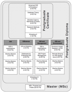
About the programme:
 The PgC course is made up of four compulsory modules and two workshops. Students who successfully complete the course will be eligible for the award of Postgraduate Certificate in GIS.
The first introductory workshop is part of the first module and serves as an introduction to GIS and the UNIGIS Programme. It may include initial training for the course software, but above all it provides an opportunity for getting to know staff and fellow students. The second workshop, which is compulsory, will be held at the end of the PgC course and is for consolidation and application of the course material, for hands-on experience, and for personal contact. You will attend this workshop during the Annual UNIGIS Conference in Amsterdam.
Modules are progressive and, although self-contained in terms of academic content, will use material developed in earlier parts of the course. The course progresses from module to module in numbered sequence.
Programme director:
Professor Henk Scholten unigis.sbe@vu.nl
Programme coordinator:
Dr. Niels van Manen n.van.manen@vu.nl
Objectives:
• Identify the linkages between technology, data, methods and organisations in the use of GIS;
• Develop competence in data representation and the use of spatial analysis techniques;
• Gain experience in the design,implementation and analysis of databases.
Programme format:
The UNIGIS curriculum is a distance learning course. This means very few contact hours with actual teaching are given during the course. The workshops are par excellence moments at which students can meet the tutors and at which actual lectures are given. In order to support the distance learning student in his/her study activities, the digital learning environment Blackboard is used and staff is equipped with webcams and microphones to support virtual contact (one-on-one and group).
Core modules:
- Advanced GIS
- Database Theory
- Geodata Capture
- Standards and Quality
- Research Methods
- Workshop Spatial Analysis
Elective modules:
Programme information
The PgC course is made up of four compulsory modules and two workshops. Students who successfully complete the course will be eligible for the award of Postgraduate Certificate in GIS.
Examination:
8 assignments + 2 workshops
Admission requirements:• University BSc/Msc with GIS: direct admission
• University BSc/MSc without GIS: 6 credits Premaster
• Bsc Higher Education: Premaster assessment + full 12 ECTS Premaster
Tuition fee: € 8800 MSc; € 6200 PgD; € 3600 PgC
Workload / Credits: 532 hours / 19 ECTS
Language: English
