About the programme:
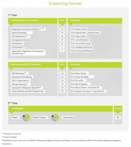
The Master degree program in Geographic Information Systems and Science functions both in e-learning or b-learning formats, and in Portuguese. It trains experts and managers to lead and guide the design and development of Geographic Information Systems and Science tailored for the needs of enterprises and public and private institutions.The program includes:- A curricular component, which consists of a set of course units, corresponding to the postgraduate program (60 ECTS), lasting two curricular semesters.
- An original scientific thesis, work project or a final report of a professional internship, carried out during the third semester, corresponding to 35 ECTS.
Programme director:
Marco Painho painho@novaims.unl.ptProgramme coordinator:
Tiago H. Moreira de Oliveira tiago.oliveira@novaims.unl.ptObjectives:
The programme trains experts and managers to lead and guide the design and development of Geographic Information Systems and Science tailored for the needs of enterprises and public and private institutions.
Programme format:
To earn the postgraduate diploma in Geographic Information Systems and Science, the students must complete 7,5 ECTS corresponding to the mandatory course unit Geographic Information Systems, and 52,5 ECTS corresponding to the elective course units. To earn the master degree in Geographic Information Systems and Science, added to these ECTS that must completed during 1st and 2nd semesters, the students must develop a scientific thesis, work project or undertake a professional internship, during the third semester, which correspond to 35 ECTS.
Students can enroll in maximum 75 ECTS in the curricular component.
Core modules:
- Geographic Information Systems and Science
Elective modules:
- Spatial Databases;
- GIS Applications;
- Cartographic Sciences;
- Geostatistics;
- Geospatial Datamining;
- GIS in Organizations;
- Open Software and GIS Programming;
- GIS Modelling;
- Remote Sensing;
- Geospatial Intelligence (GEOINT).
Programme information
The Master degree program in Geographic Information Systems and Science functions both in e-learning or b-learning formats, and in Portuguese. It trains experts and managers to lead and guide the design and development of Geographic Information Systems and Science tailored for the needs of enterprises and public and private institutions.
Examination:
Admission requirements:Qualification: Master Degree in Geographic Information Systems and ScienceTuition fee: € 3.960
Workload / Credits: 2 years
Language: Portuguese