About the programme:
 The Master of Science in GIS programme takes three years and involves the entire Diploma programme plus an additional third year in which you carry out an MSc. research project and you write a thesis. If you want to register for the Master of Science in GIS, you must have obtained the UNIGIS Diploma already.The Msc programme is aimed at middle to senior management, project managers and information technology personnel, though other suitably qualified candidates may be considered. As such, it focuses on the practical knowledge and skills required designing and implementing GIS in real situations from a scientific point-of-view.
Programme director:
Professor Henk Scholten info@unigis.nlProgramme coordinator:
Dr. Niels van Manen n.van.manen@vu.nlObjectives:
On completion of this unit, students should be able to:
- plan, design and execute an advanced, independent investigation;
- undertake data gathering with due regard for safety and risk assessment and ethical standards;
- synthesize and interpret results/outcomes in the context of the relevant peer reviewed literature;
- present the outcomes in the form of a coherently argued and well-constructed dissertation including critical reflection on the process of undertaking the research project and applying research methodologies.
Programme format:
The MSc project is student directed. The preparative programme/workshop will examine the whole process for the MSc project from problem definition to dissertation writing. This will be integrated with the assessments which will ensure (a) appropriate aims and objectives for the research project; (b) effective literature use and presentation of the project outcomes. An optional workshop covering these issues will be held at the beginning of the MSc stage but all students will be issued with a MSc guide covering this material.
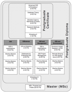
Core modules:
- Advanced GIS
- Database Theory
- Geodata Capture, Standards and Quality
- Research Methods
- Workshop Spatial Analysis
- Workshop Spatial Modelling
- Two compulsory modules from the chosen pathway plus two additional electives.
- MSc Thesis Proposal and Thesis
Elective modules:
Programme information
In the final stage of the UNIGIS MSc students write their thesis proposal and the actual thesis. The MSc programme aims to enable students to design and execute an original/ independent study in their field of GIS and in doing so to develop an in-depth knowledge of the relevant GIS literature and research activities in that field.
Examination:
The first step in the dissertation assessment is the independent assessment of two supervisors: the thesis supervisor and a second Unigis tutor. After they agree that the thesis is of sufficient quality, they will each report their findings and propose a grade. The two reports will be submitted to the Programme Director. He will assess the thesis and, together with the two supervisors, determine the grade. The student is required to defend his/her thesis before an audience (public defence) and before the Board of Examiners (private defence). Theses will be assessed on the following criteria (in random order):
• Critical evaluation of ideas and appreciation of the field of study
• Practical technique and approach
• Discussion of results
• Oral presentation
Students must be a Postgraduate Diploma (PgD) holder before starting the MSc programme.
Qualification: Master of Science in GISTuition fee: € 8800 MSc; € 6200 PgD; € 3600 PgC
Workload / Credits: 616 hours
Language: English